

Seabed Survey and Mapping Services
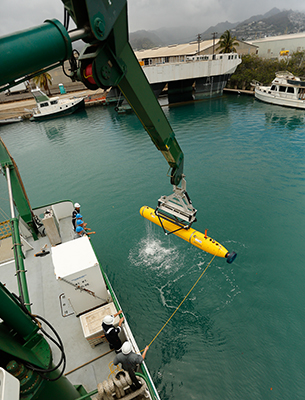
Phoenix provides comprehensive geophysical, geotechnical, and environmental survey and positioning services to support marine operations worldwide. Our experienced technicians deliver high-quality data using advanced technologies, including Remotely Operated Vehicles (ROVs), the Artemis Autonomous Underwater Vehicle (AUV), and side-scan sonar systems.
These capabilities enable our clients to make informed decisions throughout the project lifecycle—whether for route planning, site assessment, hazard identification, or infrastructure monitoring—ensuring safe, efficient, and cost-effective offshore operations.
Geophysical/Site Survey Services
Phoenix provides geophysical and site survey services to support a wide range of offshore and nearshore activities, including drill rig moves, drilling geohazard investigations, and offshore wind development. Using advanced technologies such as magnetometers, multi-beam echosounders (MBEs), and side-scan sonar, our teams can accurately detect subsurface structural features, geological layers, and buried debris, infrastructure, or utilities.
These capabilities are also valuable in municipal waterfronts, where debris from decades of construction, demolition, and abandonment may obstruct planned upgrades or rehabilitation. Phoenix’s survey solutions help clients mitigate risk, plan efficiently, and move forward with confidence.
Marine Ecological Surveys and Environmental Assessment
Phoenix provides scientifically rigorous marine ecological surveys and environmental assessment services to evaluate the potential impacts of proposed marine activities on biological communities, physical resources, and seafloor conditions. Our experienced teams deliver efficient, high-quality data collection and analysis to support regulatory compliance and responsible marine development.
In alignment with Bureau of Ocean Energy Management (BOEM) requirements, Phoenix conducts environmental surveys in areas affected by the construction, installation, and operation of offshore infrastructure—including buoys, subsea cables, meteorological towers, wind turbines, and associated support structures.
Subsea Pipeline, Umbilical, and Cable Inspections
Offshore pipeline, umbilical, and cable inspections present unique challenges due to the harsh and dynamic environments in which they operate. Phoenix meets these challenges with precision and reliability, providing high-quality inspections using Remotely Operated Vehicle (ROV) video, acoustic imaging, multibeam echosounders, and side-scan sonar.
Our integrated inspection capabilities allow for accurate leak detection, condition monitoring, and routine visual assessments—ensuring the continued integrity and performance of critical subsea infrastructure.
Route Survey Services
Route surveys are a critical component of subsea cable and pipeline installation, providing essential data for planning and risk mitigation. Phoenix conducts comprehensive route surveys using advanced tools such as multi-beam echosounders (MBEs), side-scan sonar (SSS), sub-bottom profilers (SBP), and magnetometers to deliver detailed assessments of the seafloor and subsurface conditions.
Our experienced technicians perform these surveys ahead of cable and pipelay operations or subsea construction activities—providing clients with the accurate, actionable information needed to make informed project decisions and ensure safe, efficient installations.
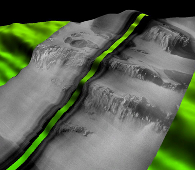
Bathymetric Mapping and Seafloor Characterization
The ocean floor is as complex as it is deep. Using high-resolution bathymetric data collected via multi-beam echosounders (MBEs)—whether ROV-mounted or deployed from over-the-side pole systems—Phoenix can accurately identify seafloor features such as flatlands, escarpments, seamounts, and deep trenches.
This detailed seafloor characterization is invaluable for a wide range of offshore applications, including dredging, trenching, sonar- or acoustics-based pipeline inspections, and pre-construction site surveys. Our bathymetric mapping services help clients better understand and navigate the subsea environment with confidence.
UXO Detection and Surveying Services
Phoenix provides specialized surveying services to locate and identify unexploded ordnance (UXO) near proposed renewable energy development sites. Our teams conduct magnetometer and gradiometry surveys using towed array systems capable of operating in a wide range of environments—from very shallow coastal zones to deep water.
These advanced detection methods help ensure safe construction and installation activities by identifying potential hazards early in the project lifecycle, supporting both regulatory compliance and operational safety.
Supporting Services
In addition to the above, Phoenix also offers the following accompanying survey-related services:
- Computer-Aided Design (CAD) and Geographical Information Systems (GIS) support
- Data processing and reporting
- Dimension control surveys (including offset measurements)
- Differential Global Positioning System (DGPS) verifications
- Quayside vessel gyro and motion sensor calibrations
- Ultra-short Baseline (USBL) calibrations
- Video recording for documentation