

Autonomous Underwater Vehicle (AUV) – Artemis
Phoenix International operates and maintains Artemis, a state-of-the-art AUV rated to 5,000 meters. We built this system for deep-water search and survey missions. It delivers high performance, flexibility, and global reach.
Artemis stays compact and highly portable. As a result, teams mobilize quickly and ship it worldwide with ease. Its small footprint also allows deployment from vessels of opportunity. This reduces cost without sacrificing capability.
Key Features
- Modular payload bays support rapid reconfiguration
- Field-swappable batteries increase uptime and reduce delays
- High-resolution sensors deliver precise mapping and detection
- Rugged design ensures reliable performance in harsh environments
With Artemis, Phoenix provides accurate, efficient, and cost-effective subsea data for commercial, government, and defense operations.
Commercial Applications
Artemis delivers consistent, high-quality survey results. It uses precision navigation, terrain-following capability, and advanced sensors. Therefore, it supports a wide range of missions:
- Mineral exploration
- Marine archaeology
- Pipeline and cable inspection
- Geophysical surveys
- Search operations
- Habitat and benthic mapping
- Route and as-built surveys
- Optical imaging and documentation
Payload Flexibility & Expert Support
Artemis adapts quickly to changing mission needs. Crews can swap between three payload configurations in the field with minimal effort. This flexibility supports everything from search operations to complex data collection.
In addition, Phoenix engineers and software teams support every deployment. They provide real-time adjustments, mission planning, and system optimization. As a result, operations stay efficient and responsive.
Acoustic Payload
The acoustic payload runs multiple systems at once. It operates a 100/400 kHz Reson 7125 multibeam echosounder alongside an Edgetech 2200 side-scan sonar and chirp sub-bottom profiler.
This setup increases data density. It also allows single-pass data collection, which improves efficiency and lowers survey costs.
Optical Payload
The optical payload uses a high-resolution Prosilica GX1920 camera. It captures detailed black-and-white imagery across a 25-square-meter area.
Teams can georeference this imagery to create accurate mosaic maps. Consequently, they gain clear visual documentation of the seafloor.
Geophysical Payload
The geophysical payload collects multiple data streams at once. It includes:
- A 3-axis magnetometer with nanotesla sensitivity
- An electric field sensor with a 3-meter dipole
- A multibeam echosounder for backscatter and bathymetry
- A CTD for water column data
Together, these sensors deliver comprehensive geophysical insight in a single mission.
System Equipment
The full Artemis system includes topside equipment, a USBL system, Launch & Recovery System (LARS), the AUV, batteries, and maintenance tools.
We package the system into 20 pieces. It weighs 20,000 lbs. and totals 1,000 cubic feet. However, each component breaks down easily. Therefore, teams can ship and deploy it quickly anywhere in the world.
Navigation
Artemis uses an integrated navigation suite. This includes an internal navigation system, Doppler velocity log, ring laser gyro, and depth sensor.
We combine these with a USBL system to deliver accurate, repeatable positioning. As a result, operators maintain precise control throughout the mission.
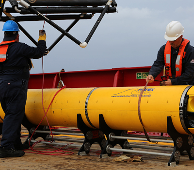
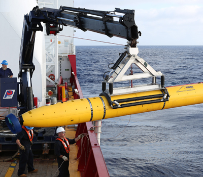
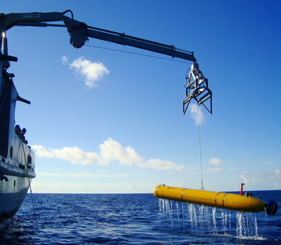
Launch & Recovery
Crews launch and recover Artemis using a designated docking head. Most vessel cranes with a 5,000-lb capacity can handle deployment.
For added flexibility, the system includes a skid-mounted articulated knuckle boom crane (Palfinger PK32002M). This provides stand-alone launch and recovery capability. Consequently, teams operate independently in a wider range of environments.